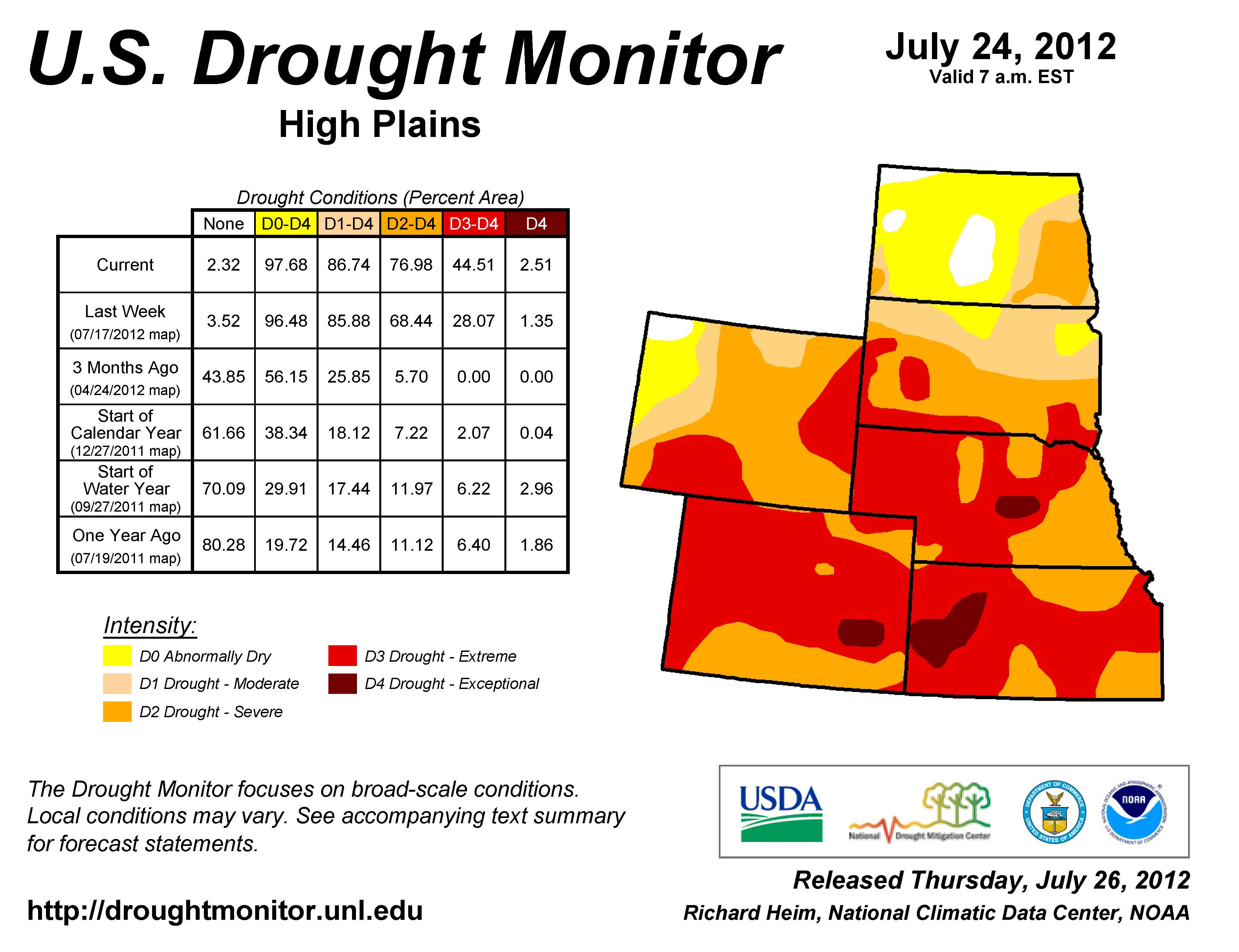
Some areas of southern South Dakota moved into the extreme drought category in the past week, but some areas of northeastern South Dakota moved out of the drought categories into the “abnormally dry” category, according to a new drought map released Thursday. (See the image above here.)
Laura Edwards, a climatologist for the South Dakota Extension service, was in southern South Dakota on Thursday to look at crop conditions.
“The corn I am looking at today is dead,” she said in a story in the Aberdeen American News. “It is not coming back. It does not matter if we get rain or not.”
The National Weather Service, which released the drought map, also has an animation of how drought conditions have spread in the past weeks. Go to this site and select the state you’d wish to see and how many weeks the animation should show.
The South Dakota Drought Task Force has set up a site with drought information: drought.sd.gov.
In Faulk County, things are looking better after much needed rains
Thanks to some timely rainfall, a little bit of cautious optimism regarding crop prospects is warranted.
In Faulkton weather observer Tom Bartholomew recorded 0.72 inches of rain from the past week.
In Wecota Randy Carlson reported variable rainfall. “In Wecota proper there was about a half inch of rain,” he said. “In the area, some had more and some had less, varying from 0.25 to a full inch or so. I’m not sure about the corn, but the rain helped out the beans a lot. We can always use more rain, though of course a lot of guys are out combining wheat right now too. I’d say the spring wheat harvest is about eighty percent done.”
In Chelsea, Dave Ortmeier reported a boon rain of 2 inches. “We got about two inches and north of us they got even more, I heard it was almost 3.5 inches or so,” he said. “Everything is looking better. I think the corn is going to end up much better than it’s looking. Wheat harvest is almost finished. Guys have been pulling about 50 to 60 bushels per acre.”
In Onaka, Shannon Waldman reported smaller rainfall numbers. “I think it was only about .42 inches in total,” he said. “Still, it greened things up again. The corn and soybeans definitely look better. Winter wheat harvest is all done and it was about 55 to 60 bushels. The guys are still plugging away at the spring wheat. It was nice to have the rain, and we could use some more.”
In Seneca, Kirk Hoefert reported 1.75 inches of rain. “South of us didn’t get as much, but 212 on north we did pretty well,” he said. “Since that rain the beans and corn have taken a turn for the better. Between us and Onaka is where most of it fell. We are greening up again and looking good. I’ve heard some of the guys talking about yields from the spring wheat and they’ve come back in the 40 to 45 area. Soon all that will be done, and the guys will be waiting on the row crops and so we just need to see those timely rains continue and we’ll get a good crop. Wouldn’t hurt if things cooled off a little bit, too.”
In Clark County, drought continues
The lack of moisture has played a significant role in Clark County. In a nutshell, the western side is very dry; the southern end is coming off a big rain over a month ago. Scott Finstad of Bradley reported 2.5 inches, and Red Obermeier at Crocker reported 1.6 inches.
The city of Clark officially received 0.42 this last week and is fairly typical of the critically dry conditions of the country, as very little rain has been reported during July, with temperatures soaring to near 100 degrees and high humidity for this time of year.
Corn growers are hoping for moisture and fewer heat units, and as usual for this time of year, almost every field needs rain, and almost each field differs from the one next to it.
Temperatures stateside are reported as being record or near record levels for the first six months of the year. These warmer temperatures, combined with a limited soil moisture bank to draw from and the recent very dry conditions, have increased the drought severity and impacts very quickly in the last several weeks.

Leave a Reply